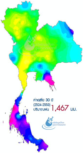
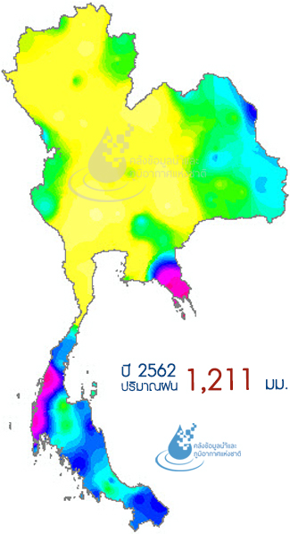
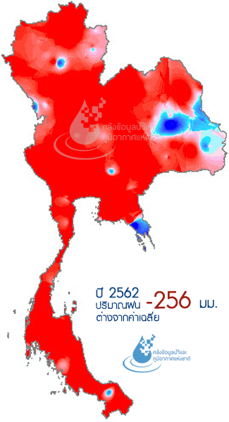
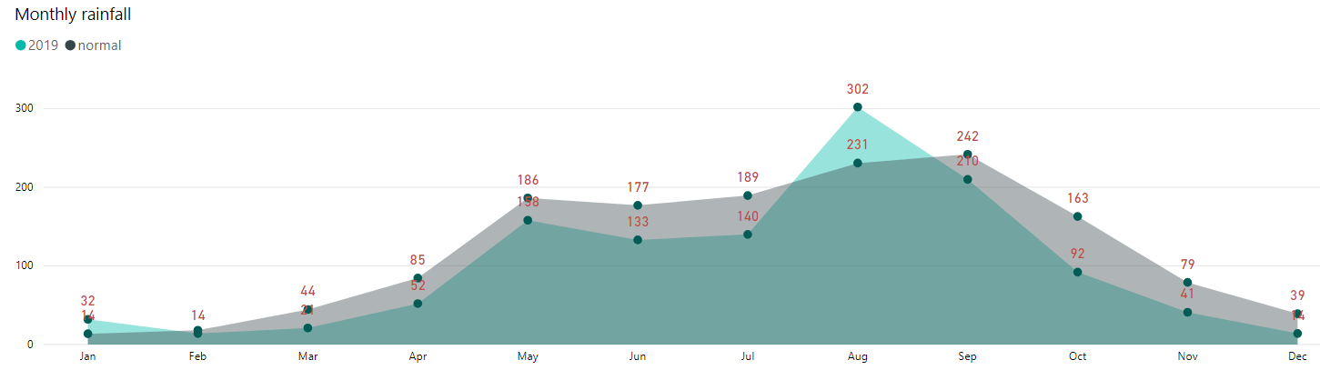
ปี 2562 ประเทศไทยมีฝนตกเฉลี่ยทั้งประเทศประมาณ 1,211 มิลลิเมตร น้อยกว่าปกติประมาณ 17% พื้นที่ส่วนใหญ่ของประเทศมีฝนตกน้อยกว่าปกติ ส่วนฝนตกมากกว่าปกติเกิดขึ้นในบางพื้นที่เท่านั้น โดยเฉพาะภาคตะวันออกเฉียงเหนือบริเวณจังหวัดอุบลราชธานี อำนาจเจริญ มุกดาหาร ยโสธร ร้อยเอ็ด กาฬสินธุ์ มหาสารคาม เนื่องจาก
พื้นที่ดังกล่าวได้รับอิทธิพลจากพายุโซนร้อนโพดุลที่ส่งผลกระทบกับพื้นที่ดังกล่าวในเดือนสิงหาคม ซึ่งเป็น 1 ใน 2 เดือนของปี 2562 ที่ฝนตกมากกว่าปกติ นอกจากนี้เดือนมกราคมเป็นอีกเดือนหนึ่งซึ่งมีฝนตกมากกว่าปกติ ซึ่งฝนตกส่วนใหญ่กระจุกตัวอยู่บริเวณภาคใต้ ส่วนอีก 10 เดือนที่เหลือ มีฝนตกน้อยกว่าปกติทุกเดือน โดยเฉพาะอย่างยิ่งในช่วงฤดูฝน
ระหว่างเดือนพฤษภาคมถึงเดือนตุลาคม ที่โดยปกติจะเกิดฝนตกหนักบริเวณตอนบนของประเทศและเป็นช่วงเวลาแห่งการกักเก็บน้ำเพื่อเตรียมไว้ใช้ในช่วงฤดูแล้ง แต่ปีนี้ฝนตกน้อยกว่าปกติอย่างมากเกือบทุกเดือน ทำให้กักเก็บน้ำไว้ได้น้อย ซึ่งอาจส่งผลทำให้เกิดสถานการณ์ขาดแคลนน้ำในปี 2563
In 2019, Thailand had an average annual rainfall of 1,211 mm, which was approximately 17% less than normal. Most areas of the country experienced less rainfall than usual. More than normal rainfall occurred in some areas only, especially in the northeastern region, Ubonratchathani, Amnatcharoen, Mukdahan, Yasothon, Roi-et, Kalasin and Mahasarakam provinces, as the
area was influenced by the tropical storm “PODUL” that affected the area in August, which was one of the two months in 2019 having monthly rainfall higher than normal. January was another month with more rain than usual, and the rain mostly concentrated in the southern region. For the other 10 months, there was less rain than usual every month, especially during the rainy season
between May and October, when it usually rains heavily in the upper part of the country, and it is a time of water retention for use during the dry season. This past year, however, it rained much less than usual almost every month resulting in little water retention, which may lead to water shortage in 2020.
Remark : Calculate rainfall volume by using Inverse Distance Weighting Method and raw data from main weather stations
of Thai Meteorological Department
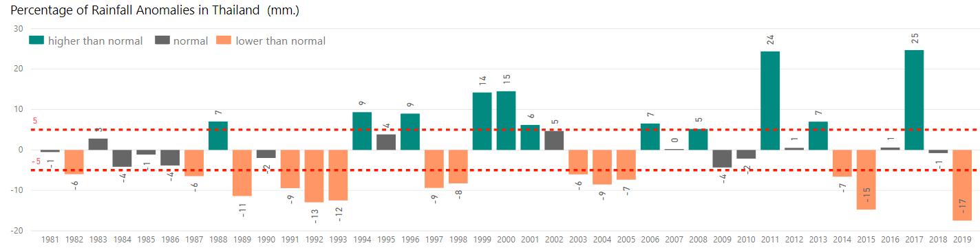
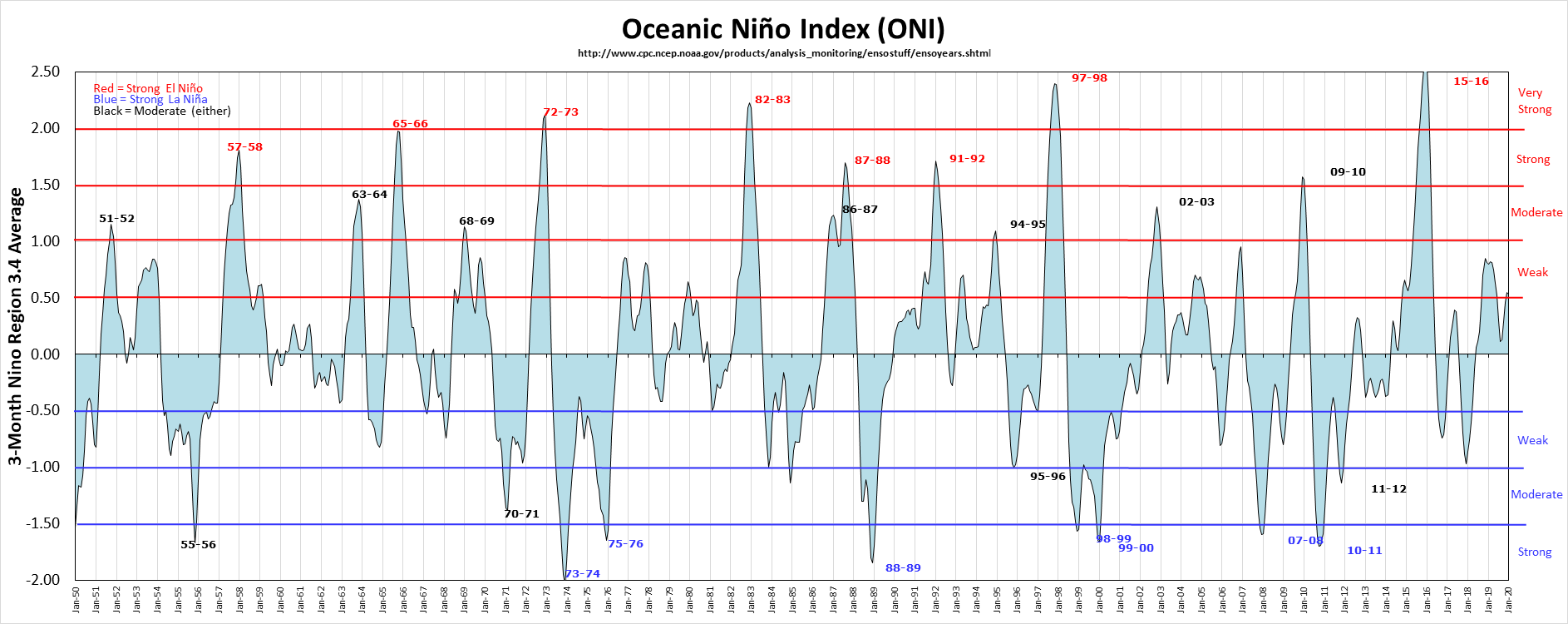
หากวิเคราะห์สถานการณ์ฝนที่เกิดขึ้นในอดีต จะเห็นได้ว่าช่วงทศวรรษที่ผ่านมา ปริมาณฝนของประเทศไทยมีความแปรปรวนค่อนข้างสูง โดยในช่วงปี 2552 - 2553 มีฝนตกน้อย ส่งผลทำให้เกิดภัยแล้งรุนแรงในหลายพื้นที่โดยเฉพาะพื้นที่ลุ่มน้ำเจ้าพระยา ซึ่งตรงกันข้ามกับปีต่อมาที่มีฝนตกเกินค่าปกติไปค่อนข้างมาก ส่งผลทำให้เกิดมหาอุทกภัยในปี 2554 น้ำท่วมในทุกภาคของประเทศ หลังจากนั้นอีก 2 ปี เกิด
สถานการณ์ฝนตกน้อยผิดปกติต่อเนื่องในปี 2557-2558 ส่งผลทำให้เกิดภัยแล้งรุนแรงขึ้นอีกครั้ง โดยเฉพาะปี 2558 ที่มีฝนตกน้อยที่สุดเป็นประวัติการณ์ เนื่องจากได้รับผลกระทบจากปรากฎการณ์เอลนีโนกำลังแรงมาก (Very Strong Elnino / Super Elnino) แต่หลังจากนั้นอีกเพียงปีเดียวกลับเกิดสถานการณ์ฝนตกมากที่สุดเป็นประวัติการณ์ในปี 2560 โดยที่ปริมาณฝนใกล้เคียง
ปี 2554 แต่ต่อมาในปี 2561 ปริมาณฝนกลับลดลงอย่างมากอีกครั้งและลดลงต่อเนื่องถึงปี 2562 ที่ฝนตกน้อยที่สุดทำลายสถิติปี 2558 ซึ่งส่วนหนึ่งเกิดจากการได้รับอิทธิพลจากปรากฏการณ์เอลนีโนกำลังอ่อน (Weak Elnino) ซึ่งทั้งหมดนี้แสดงให้เห็นอย่างชัดเจนว่าความถี่ของการเกิดฝนตกน้อยกว่าปกติสลับกันกับฝนตกมากกว่าปกติมีเพิ่มมากขึ้น
An analysis of historical rainfall data showed that rainfall in Thailand had relatively high variability in the past decade. During 2009-2010, Thailand had a continuously very low annual rainfall, which resulted in severe drought in many areas especially Chao Phraya River Basin, in contrast to the following year, 2011, that had a lot more rain than normal leading to the great flood that
flooded in all regions of the country. Two years later, continuous irregular rainfall in 2014-2015 resulted in severe drought again, with 2015 being the year of Thailand’s record low rainfall, due to the Very Strong Elnino / Super Elnino effect. But only one year after that, Thailand had a new record high annual rainfall in 2017 with the amount of rain close to the year 2011. Later in 2018,
the amount of rain dropped dramatically again and continuously decreased to the year 2019 with the least rainfall, breaking the 2015 record, in part due to the influence of the Weak Elnino phenomenon. All of these clearly show that the alternation between low rainfall events and high rainfall events occurred at a higher frequency.
Remark : Calculate rainfall volume by using Inverse Distance Weighting Method and raw data from main weather stations
of Thai Meteorological Department
กราฟแสดงการเกิดปรากฎการณ์เอลนิโนและลานินาตั้งแต่อดีตจนถึงปัจจุบัน
Elnino and Lanina phenomenon
พายุเป็นหนึ่งในปัจจัยที่ทำให้เกิดฝนมากหรือฝนน้อยในประเทศไทย ปี 2562 มีพายุเคลื่อนตัวเข้าสู่ประเทศไทยจำนวน 3 ลูก ซึ่งเท่ากับค่าเฉลี่ยสถิติพายุหมุนเขตร้อนที่เคลื่อนเข้าสู่ประเทศไทยในรอบ 69 ปี พายุทั้ง 3 ลูก ได้แก่ พายุโซนร้อน “ปาบึก” (PABUK) ซึ่งเคลื่อนเข้าสู่ประเทศไทยในขณะที่มีกำลังแรงอยู่ในระดับพายุโซนร้อน ส่งผลทำให้เกิดฝนตกในหลายพื้นที่ของภาคใต้ในช่วงเดือนมกราคม ซึ่งพายุลูกนี้ได้ทำสถิติกลายเป็นพายุลูกแรกที่เคลื่อน
ตัวเข้าภาคใต้ในช่วงเดือนมกราคมตั้งแต่ประเทศไทยมีการบันทึกข้อมูล ส่วนพายุอีก 2 ลูก เคลื่อนเข้าสู่ประเทศไทยในขณะที่มีกำลังแรงอยู่ในระดับพายุดีเปรสชัน ได้แก่ พายุโซนร้อน “วิภา” (WIPHA) ที่เคลื่อนตัวเข้าสู่บริเวณภาคเหนือในช่วงต้นเดือนสิงหาคม และพายุโซนร้อน “โพดุล” (PODUL) ที่เคลื่อนตัวเข้าสู่บริเวณภาคตะวันออกเฉียงเหนือของประเทศไทยในช่วงปลายเดือนสิงหาคม ซึ่งอิทธิพล
จากพายุทั้ง 3 ลูก ส่งผลทำให้เกิดน้ำท่วมในหลายพื้นที่ในเดือนมกราคม สิงหาคม กันยายน และตุลาคม รวมพื้นที่ประมาณ 5 ล้านไร่ ครอบคลุมพื้นที่ 40 จังหวัด 415 อำเภอ 2,587 ตำบล (ข้อมูลจากภาพถ่ายดาวเทียม) โดยเฉพาะภาคตะวันออกเฉียงเหนือที่มีจังหวัดที่ถูกน้ำท่วมถึง 19 จังหวัด ซึ่งจังหวัดร้อยเอ็ดมีพื้นที่ถูกน้ำท่วมมากที่สุด รองลงมาคือจังหวัดยโสธร และจังหวัดอุบลราชธานี
Storm is one of the factors that causes more rain or little rain in Thailand. In 2019, there were three storms attacking Thailand which is equal to the average number of tropical cyclones that moved into Thailand in 69 years. One of the three storms is tropical storm “PABUK” which attacked Thailand while the strength was at the tropical storm level and caused heavy rainfall in many areas of the southern region during January. This
storm has made it the first storm to move to the south since Thailand has recorded data. The other 2 storms attacked Thailand while the strength was at the depression level. They were tropical storm “WIPHA” that attacked the northern region in early August, and tropical storm “PODUL” that moved into the northeastern region of Thailand at the end of August. The influence of these three storms caused flooding in many areas in
January, August, September and October, totaling an area of about 5 million rai, covering 40 provinces, 415 districts, and 2,587 sub-districts (data from satellite images). In particular, 19 provinces in the northeastern region were flooded, of which Roi-Et had the largest flood areas, and next were Yasothon and Ubonratchathani.
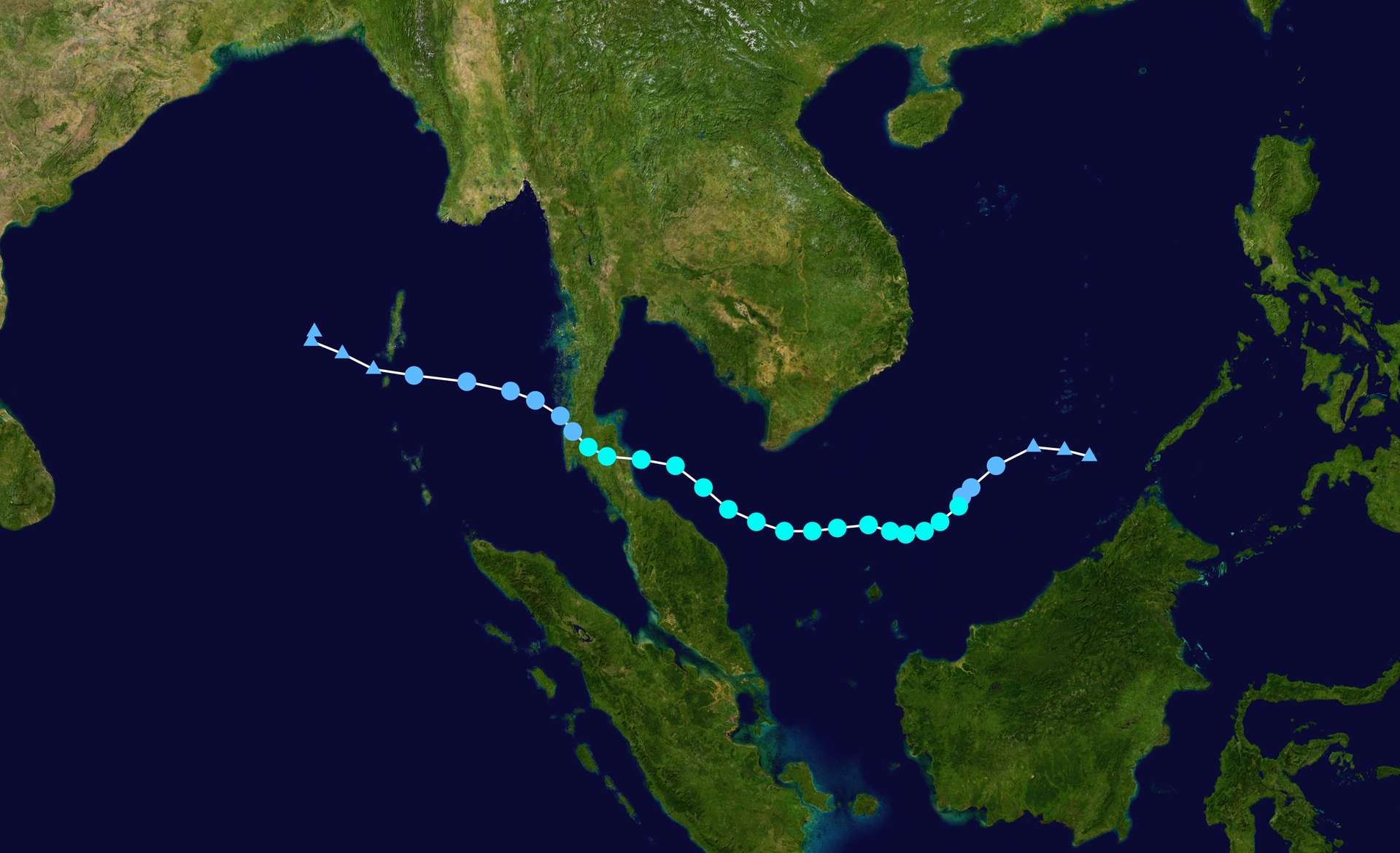 Tropical Storm "PABUK"
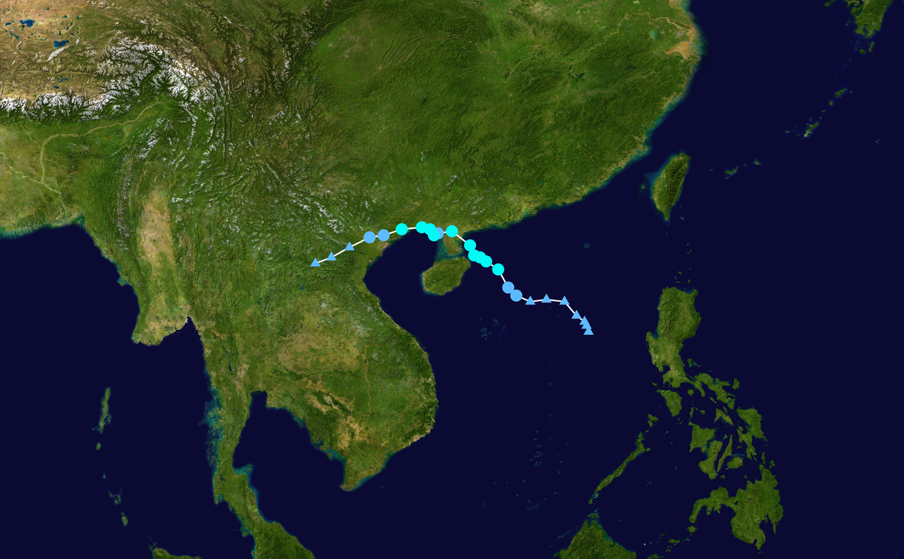 Tropical Storm "WIPHA"
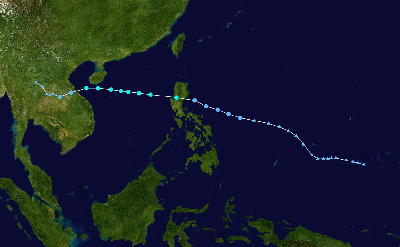 Tropical Storm "PODUL"
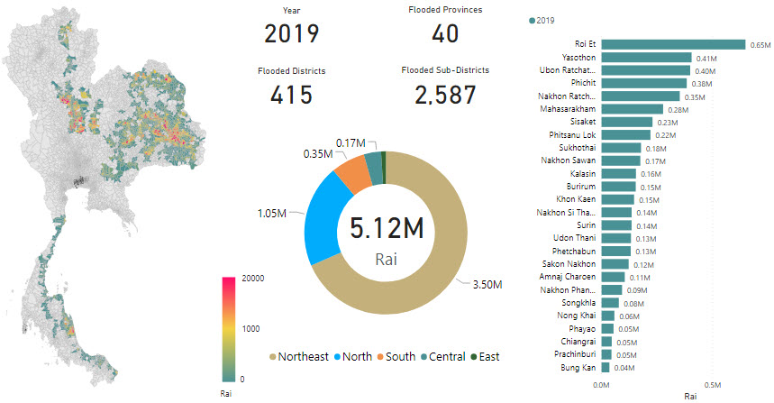
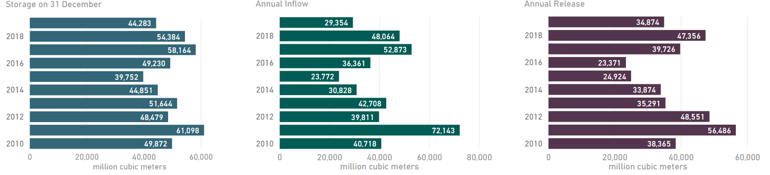
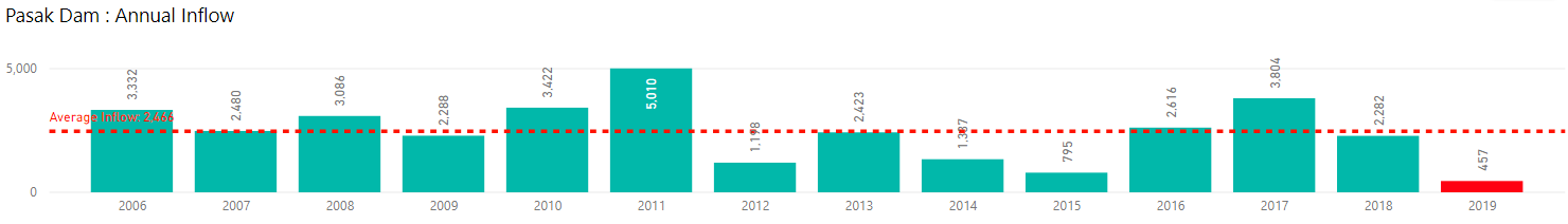
นอกจากนี้อิทธิพลของพายุยังส่งผลทำให้เขื่อนลำปาว จ.กาฬสินธุ์ และเขื่อนสิรินธร จ.อุบลราชธานี มีน้ำไหลลงค่อนข้างมาก แต่ปริมาณน้ำไหลลงเขื่อนขนาดใหญ่รวมทั้ง 35 แห่งทั่วประเทศมีเพียง 29,354 ล้านลูกบาศ์เมตรเท่านั้น เนื่องจากเขื่อนส่วนใหญ่มีน้ำไหลลงค่อนข้างน้อย โดยเฉพาะเขื่อนป่าสักชลสิทธิ์
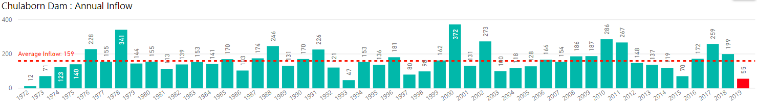
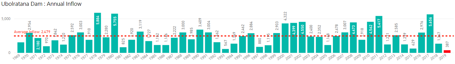
จ.ลพบุรี เขื่อนอุบลรัตน์ จ.ขอนแก่น และเขื่อนจุฬาภรณ์ จ.ชัยภูมิ ที่มีน้ำไหลลงเขื่อนน้อยที่สุดตั้งนับตั้งแต่มีการสร้างเขื่อน ด้วยเหตุนี้จึงทำให้เขื่อนส่วนใหญ่ต้องนำน้ำต้นทุนของปีก่อนหน้าออกมาใช้ ส่งผลทำให้ปริมาณน้ำกักเก็บคงเหลือสิ้นปีมีเหลืออยู่เพียง 44,283 ล้านลูกบาศก์เมตร โดยเฉพาะภาค
ตะวันออกที่มีน้ำกักเก็บในเขื่อนเหลือน้อยที่สุดในรอบ 10 ปี อีกทั้งลุ่มน้ำเจ้าพระยา ซึ่งมีอาณาเขตครอบคลุมทั้งภาคเหนือและภาคกลาง มีน้ำกักเก็บคงเหลืออยู่น้อยเช่นกัน โดยเฉพาะเขื่อนป่าสักชลสิทธิ์ ที่เป็น 1 ใน 4 เขื่อนหลักของลุ่มน้ำเจ้าพระยา มีปริมาณน้ำกักเก็บเหลือน้อยที่สุดนับตั้งแต่มีการสร้างเขื่อน
Moreover, the influence of the storms also caused quite large amount of water to flow into Lampao Dam at Kalasin Province and Sirindhorn Dam at Ubonratchathani Province. But the total inflow at 35 large dams around the country was only 29,354 million cubic meters because most of the dams had relatively low inflow of water, especially Pasak Cholasit Dam at Lopburi Province,
Ubolratana Dam at Khonkaen Province and Chulabhorn Dam at Chaiyapum Province which had the least water inflow since the construction of the dam. For this reason, most dams had to release previous year’s water from storage. This resulted in only 44,283 million cubic meters of water remaining in storage at the end of 2019, especially in the eastern region there was
the least amount of water in the dam in the past 10 years. For the Chao Phraya River Basin which covers both northern and central regions, there was little water remaining as well, especially, Pasak Cholasit Dam, which is one of the four main dams of Chao Phraya River Basin had the lowest water storage since the construction of the dam
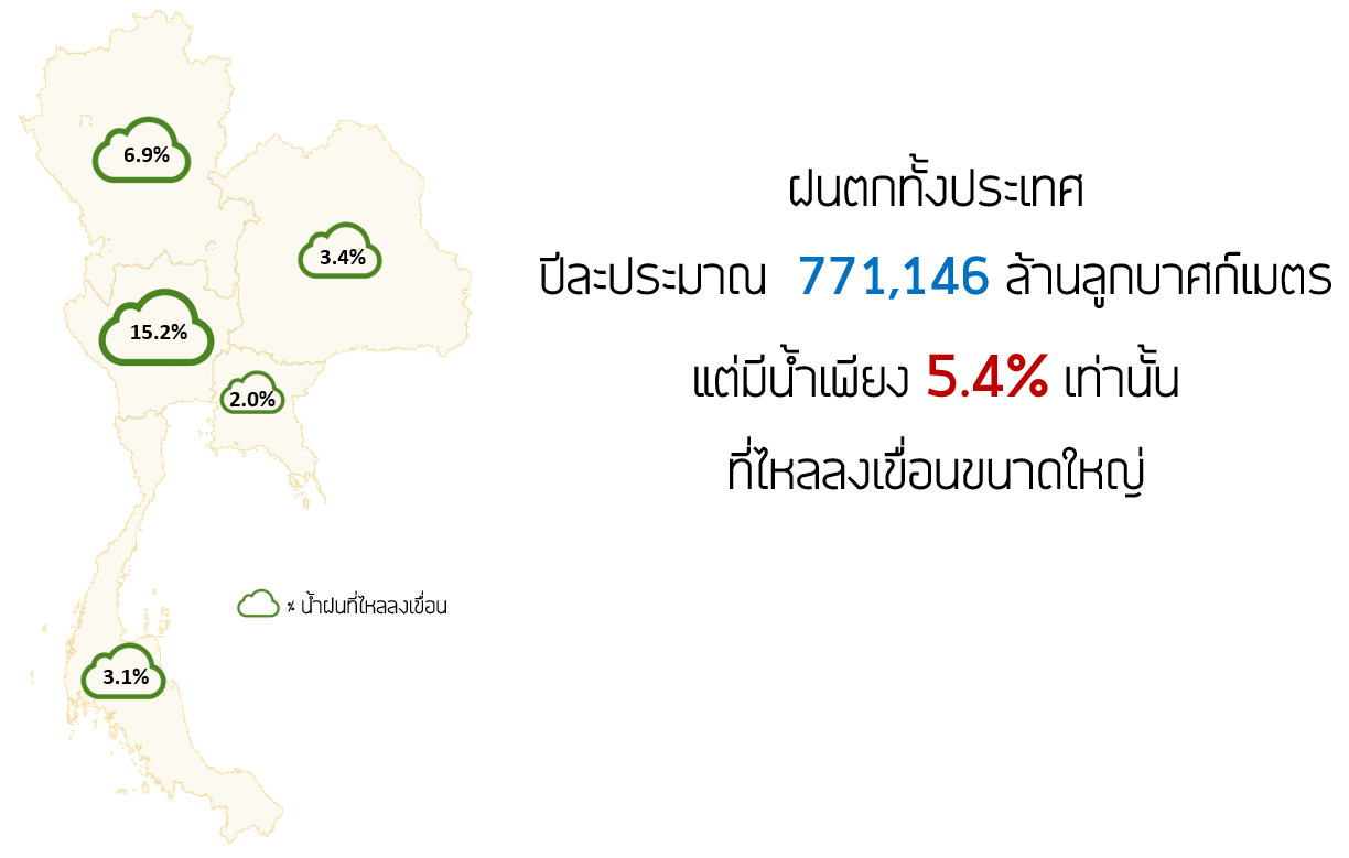
เมื่อวิเคราะห์ปริมาณฝนที่ตกกับปริมาณน้ำที่ไหลเข้าเขื่อนเฉลี่ยในช่วง 10 ปี ที่ผ่านมา ประเทศไทยมีฝนตกปีละประมาณ 771,146 ล้านลูกบาศก์เมตรต่อปี คิดเป็นปริมาณน้ำท่าประมาณ 215,150 ล้านลูกบาศก์เมตร ซึ่งบางส่วนของน้ำท่าที่ไหลลงเขื่อนขนาดใหญ่มีอยู่ประมาณ 41,663 ล้านลูกบาศก์เมตร หรือประมาณ 5.4% ของฝนที่ตกเท่านั้น ทั้งนี้เขื่อนขนาดใหญ่ทั้งประเทศมีความจุรวมกันอยู่ที่ประมาณ
70,926 ล้านลูกบาศก์เมตร หรือมีน้ำไหลลงเขื่อนเพียง 59% ของความจุเขื่อนเท่านั้น นอกจากนี้ปริมาณฝนที่ตกมีความแปรปรวนค่อนข้างสูง ฝนตกไม่สม่ำเสมอ ผิดที่ผิดเวลา ทำให้ปริมาณน้ำที่ไหลลงเขื่อนขนาดใหญ่ที่เป็นโครงสร้างน้ำหลักของประเทศมีความแปรปรวนสูงตามไปด้วย ดังนั้นจึงมีความจำเป็นต้องพัฒนาและฟื้นฟูแหล่งกักเก็บน้ำอื่นให้สามารถใช้งานได้อย่างมีประสิทธิภาพเพื่อช่วยเสริม
เขื่อนขนาดใหญ่ซึ่งเป็นโครงสร้างหลัก ไม่ว่าจะเป็นอ่างเก็บน้ำขนาดเล็ก แก้มลิง ห้วย หนอง คลอง บึง บ่อต่าง ๆ เพื่อช่วยรองรับน้ำฝนกรณีฝนตกผิดที่ รวมถึงยังสามารถช่วยลดน้ำหลากกรณีเกิดฝนตกหนักผิดปกติอีกด้วย รวมถึงเพื่อเป็นการเตรียมรับมือกับสถานการณ์ฝนที่อาจมีความแปรปรวนมากขึ้นในอนาคต
An analysis of rainfall average and inflow average in the past 10 years showed that Thailand had annual rainfall of 711,146 million cubic meters with annual runoff of 215,150 million cubic meters. Only 41,663 million cubic meters of runoff or 5.5% of annual rainfall flew into large reservoirs. The large reservoirs in the entire country have a combined capacity of approximately 70,926
million cubic meters, so water flew into reservoirs at only 59% of the capacity. Furthermore, rainfall had irregularity and quite high variability in terms of volume, area and time period causing the inflow into large reservoirs, which are the main water storage of the country, to have high variability too. Therefore, it is necessary to develop and restore other water retention
areas, such as small reservoirs, monkey cheeks, ravines, swamps, canals, ponds, etc., so that they can be used efficiently to keep rainwater when rain is outside catchment area of large reservoirs. This will help support main water storage, reduce and prevent flood caused by unusually heavy rain, as well as prepare for situation with high rainfall variability in the future.