

คลังข้อมูลสภาพน้ำ

| | | คลังข้อมูลสภาพน้ำ | | |
| Strike against Thailand from 1951 to present | Weekly Report Thailand's Flood History Since 2002
Thailand's Drought History Thailand's Flood and Dry Area's Survey | |
 | ||
| [Information] [Trace] Require Internet Explorer (IE) 6.0 and SVG plugin. |
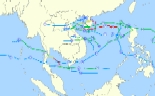
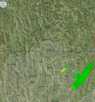
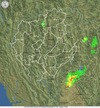
| Current Storm Tracking Near Thailand | |||||
Status :  | |||||
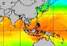
 Weather Satellite Images from MTSAT-2, Mpeg provided by Kochi U.   | Storm Tracking West Pacific provided by University College London | Storm Tracking Indian Ocean provided by University College London | 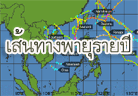 Storm Tracking YearlySummaries: 2015, 2014, 2013, 2012, 2011, 2010, 2009, 2008, 2007, 2006, 2005, 2004, 2003, 2002, 2001, 2000 provided by Hawaii U.,Weather Underground, Inc. | ||
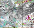
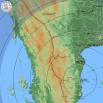
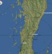
| Weather Map | |||||
  |   |   |   | ||
| provided by Thai Meteorological Department | |||||
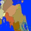
| Weather Map at 0.6 and 1.5 km above Sea Level by WRF-ROMS Model | |||||
 Pressure Map  |  Upper Wind Map |  Vertical Wind at 5.0km above Sea Level by WRF-ROMS Model | |||
| provided by Hydro and Agro Informatics Institute | |||||
 Sea Surface Temperature Sea Surface TemperatureThailand  Indian-Northern  World  provided by Ocean Weather inc. |  Change in Semi-Monthly Sea Surface Temperature provided byHydro and Agro Informatics Institute | 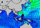 Wave Height with Wave Direction Wave Height with Wave Direction
|  Sea Surface Height Anomalies from Satellite Image Jason-1 GFO and ENVISAT
| |||||||||||||
| [Digital-Typhoon] Collect satellite typhoon images to study pattern analysis and prediction. |

 |  |  | |
 |  |  |  |
 Precipitaion Forecasts | |
| provided byHydro and Agro Informatics Institute | |
 OmKoi 240Km  on Local Time  |  PiMai 240Km  on Local Time  |  Sattahip 240Km  on Local Time  |  ChaAm 240Km  on Local Time  |
| Daily Operation Report. |
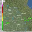
 | Rain accumulation map showing online rainfall data,updated hourly from Royal Irrigation Department, Advance Info Service and Hydro and Agro Informatics Institute | 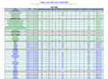 | Telemetering data showing online weather data,updated hourly Central & East coast Northeast Northern Southern from . Royal Irrigation Department., Advance Info Service | 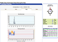 | Telemetering in palace showing online data from telemetering, updated hourly Jitralada palace Klai Kangwon palace Chung Hua Mon farm from Hydro and Agro Informatics Institute |
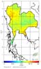 | Interpolated Map showing temperature,humidity andair pressure in the Northern region by Inverse Distance Weighting method updated hourly from Advance Info Service and Hydro and Agro Informatics Institute |
 Terra NDVI 1 km   |  Terra NDVI 2005 |  AQUA NDVI 1 km   |  AQUA NDVI 2005 | Normalized Difference Vegetation Index from TERRA and AQUA Satellites MODIS System from USDA (United States Department of Agriculture) | |
 AFWA Surface  |  AFWA Sub-Surface  |  WMO Surface  |  WMO Sub-Surface  | Soil Moisture from USDA (United States Department of Agriculture) *AFWA (Air Force Weather Agency) WMO (World Meteorological Organization) | |
 AFWA Precipitation  |  AFWA Decadal Percent Normal Precipitation  |  WMO Precipitation  |  WMO Decadal Percent Normal Precipitation  | Precipitation from USDA (United States Department of Agriculture) *AFWA (Air Force Weather Agency) WMO (World Meteorological Organization) |
 Rain Accumulations  provided By Naval Research Lab,CA | 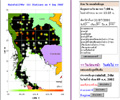 Thailand Weather data showing 118 stations from Thai Meteorological Department. |  Rainfall Distribution (1950-1997) in Each month All year Chaopaya basin |
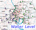
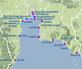
 | Basin data showing discharge Chaopraya Basin Chi-Mun Basin Khong Basin online data updated daily from Royal Irrigation Department. |  | River Basin data showing rainfall and waterlevel online updated hourly from Royal Irrigation Department
| ||||||||||||||
| | Klong Sanamchai Data (Samutsakorn) showing waterlevel data online updated from Royal Irrigation Department.  telemetering telemetering  website website |  | Storage Dams data showing status of Storage Dams online updated daily Inflow of 5 Dams on 2016 Storage of 5 Dams on 2016 Released of 5 Dams on 2016 from Royal Irrigation Department. | ||||||||||||||
 | Hydro Power Dams data showing status of Hydro Power Dams online updated daily from Electricity Generating Authority of Thailand. |  | Medium storage dams data showing status of Medium storage dams online updated daily from Royal Irrigation Department. | ||||||||||||||
 | Hydro Power Dams data showing status of Hydro Power Dams online updated hourly from Electricity Generating Authority of Thailand. | 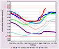 | Storage Graph of Bhumibol Dam in 8 years Sirikit Dam in 8 years Srinagarind Dam in 8 years Pasak Dam in 8 years ChaoPraya Dam in 8 years from Royal Irrigation Department. | ||||||||||||||
 | Bangkok Waterlevel data showing waterlevel online data at watergate online updated hourly from Bangkok Metropolitan Administration. | 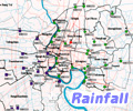 | Bangkok Rainfall data showing rainfall online data updated every 15 minutes from Bangkok Metropolitan Administration. | ||||||||||||||
 | Sea Level Forecasting showing Sea Level forecasting data hourly from Bangkok Metropolitan Administration. and Hydrographic Department Royal Thai Navy | 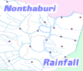 | Nonthaburi Rainfall data Temporaly subsituted BMA rainfall telemetering systems, by using Nonthaburi Telemetering System from Nonthaburi | ||||||||||||||
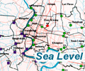
 | Sea Level Data and Forecasting online data updated hourly from Hydrographic Department Royal Thai Navy and Marine Department | ||||||||||||||||
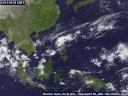
| The most up to date weather image from GOES9 Satellite. This page is refreshed every ten minutes. Source: Kochi University. |


