


| Water Watch |
|
Hydro Information
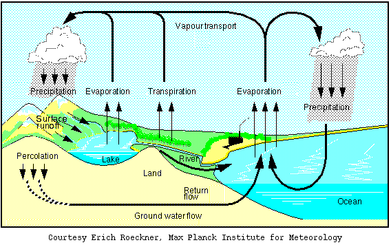
This page is a collection of water data critical for the analysis and monitoring of Thailand water resource, and is a follow up from the Weather Watch. Data is organized in a way to follow water cycle, starting from rainfall and other meteorological data from ground measurements, radar, and satellite imagery. After that, surface water data is shown, both of reservoirs, stream network and stream flow data. Rainfall and water level in Bangkok represents the water situation downstream in urban area. Finally, both observed and forecasted sea level is presented. Water watch supports the flood and drought risk management and the effective and sustainable water resource planning. Here, the water data is divided into 7 groups as followed: Group 1: Meteorological data from ground stations. Meteorological data include rainfall, temperature, solar radiation, relative humidity, and wind speed from automatic weather stations developed by HAII and from the TMD (Thai Meteorological Department) weather stations. Group 2: Radar network. Radar imagery data covers every region of the country. If any areas have a concentrated group of colors, according to the color scale of the radar image, that area is expected to have heavy rainfall. Sources of radar images are TMD, Bureau of Royal Rainmaking and Agricultural Aviation, and Department of Drainage and Sewerage. Group 3: Data derived from satellite imagery. 1) Daily rainfall distribution represents spatial distribution and intensity of rainfall. 2) Normalized Difference Vegetation Index is an indicator of available moisture. Green areas have high available moisture while brown area indicates the opposite. 3) Spatial soil moisture distribution. Green areas have high surface or sub-surface soil moisture while the brown color indicates low soil moisture. 4) 10-day cumulative rainfall distribution represents the spatial distribution of cumulative rainfall in the last 10 days. Diagrams of decadal percent of normal precipitation indicate regions where the 10-day rainfall was above (blue color) or below (brown color) the 30-year normal. Group 4: Reservoir storage and water level. It shows the summary of water conditions in large and medium reservoirs across the country from the past to the present. Sources are Royal Irrigation Department and the Electricity Generating Authority of Thailand. Group 5: Stream network and hydrological data for all basins. Stream flow rate and water level are measured by SCADA system and stream gauges. Stream network diagram for Chao Phraya river basin is presented. Group 6: Rainfall and water level in Bangkok. Rainfall and water level in Bangkok is reported on a 15-minute interval from the Department of Drainage and Sewerage. Group 7: Sea level measurement and prediction. Sea level is automatically measured every 10 minutes by telemeters developed by HAII. Hourly observed sea level data is from Marine Department. Predicted sea level is computed by Hydrographic Department. |
| แก้ไขล่าสุด ใน วันอาทิตย์ที่ 09 กุมภาพันธ์ 2014 เวลา 15:55 น. |